


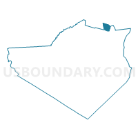
Voting District 150021, Orange County, New York
About
Outline

Summary
| Unique Area Identifier | 633822 |
| Name | Voting District 150021 |
| County | Orange County |
| State | New York |
| Area (square miles) | 4.35 |
| Land Area (square miles) | 3.66 |
| Water Area (square miles) | 0.69 |
| % of Land Area | 84.07 |
| % of Water Area | 15.93 |
| Latitude of the Internal Point | 41.58668340 |
| Longtitude of the Internal Point | -74.10511340 |
Maps

Graphs
Select a template below for downloading or customizing gragh for Voting District 150021, Orange County, New York


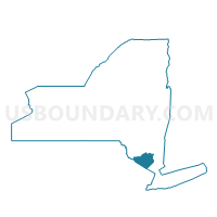
Neighbors
Neighoring Voting District (by Name) Neighboring Voting District on the Map
- Voting District 130003-130005, Ulster County, NY
- Voting District 150018, Orange County, NY
- Voting District 150019, Orange County, NY
- Voting District 180002, Ulster County, NY
- Voting District 180006, Ulster County, NY
Top 10 Neighboring County Subdivision (by Population) Neighboring County Subdivision on the Map
- Newburgh town, Orange County, NY (29,801)
- Shawangunk town, Ulster County, NY (14,332)
- Plattekill town, Ulster County, NY (10,499)
Top 10 Neighboring Unified School District (by Population) Neighboring Unified School District on the Map
Top 10 Neighboring State Legislative District Lower Chamber (by Population) Neighboring State Legislative District Lower Chamber on the Map
Top 10 Neighboring State Legislative District Upper Chamber (by Population) Neighboring State Legislative District Upper Chamber on the Map
Top 10 Neighboring 111th Congressional District (by Population) Neighboring 111th Congressional District on the Map
Top 10 Neighboring Census Tract (by Population) Neighboring Census Tract on the Map
- Census Tract 9540, Ulster County, NY (5,019)
- Census Tract 101.02, Orange County, NY (4,856)
- Census Tract 9554, Ulster County, NY (4,601)
- Census Tract 101.01, Orange County, NY (4,414)